HAITI, Tropical Storm "Jeanne", 21-24 September 2004
CLOSE-UP OVER SPECIFIC TOWNS
Speckle filtered RADARSAT-1 images, and the maps below, are processed by ParBleu Technologies Inc.
All images and maps are produced in cartographic projection UTM WGS 1984 (Zone 18).
The spatial resolution is 12.5 meters x 12.5 meters.
Notes for the interpretation :
- RADARSAT-1 multitemporal colour composition : The bright dots (whatever their colour) on the following satellite radar images (with the exception of the ones located on the crests of the mountains), correspond to the presence of houses or buildings.
Therefore, the interpretation keys that are given in the following apply only to these bright dots, which correspond to housing and infrastructures.
The variation of tones within extended areas --and particularly within the mountains-- must not be interpreted according to these keys.
- "LANDSAT-7 + Change detection" maps : Colours correspond to areas where significant changes are detected in the RADARSAT-1 time series. On the other hand, grey tones correspond to areas where no significant changes are detected.
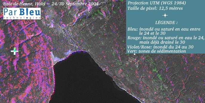
BAIE DE HENNE
The size of the area shown is 8.6 x 4.4 kilometers.
UTM geographic coordinates (WGS 1984 Zone 18Q) :
- upper left corner : northing = 2177157 / easting = 684386
- bottom right corner : northing = 2172832 / easting = 692936
Interpretation of the RADARSAT-1 colour composition :
- Pink: flooded by mudflows on September 24th; mud sedimentation observed on September 30th.
- Green: areas totally flooded by water on September 24th; water had recessed on September 30th.
- Blue: population moves; new emergency settlements on September 30th.
- Red: total destruction.
- White: untouched buildings.

Interpretation of the "LANDSAT-7 + change detection" map :
- Violet & pink: Areas flooded or water-saturated during the whole observation period (24-30 September).
- Blue: Areas flooded or becoming water-saturated in the period between the 24th and the 30th.
- Red: Areas flooded or water-saturated on September 24th, and drained on September 30th (flood recession).
- Green : Sedimentation areas and mud deposits.
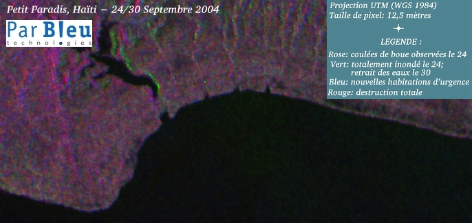
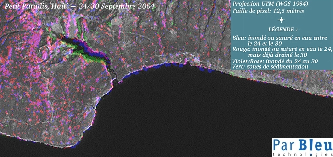
PETIT PARADIS
The size of the area shown is 8.6 x 4.1 kilometers.
UTM geographic coordinates (WGS 1984 Zone 18Q) :
- upper left corner : northing = 2174507 / easting = 694386
- bottom right corner : northing = 2170457 / easting = 702961
Interpretation of the RADARSAT-1 colour composition :
- Pink: flooded by mudflows on September 24th; mud sedimentation observed on September 30th.
- Green: areas totally flooded by water on September 24th; water had recessed on September 30th.
- Blue: population moves; new emergency settlements on September 30th (though confusions are possible here with relief-induced artefacts).
- Red: total destruction.
The village is barely visible in the radar images. Nevertheless, it seems that it was flooded on September 24th.
Interpretation of the LANDSAT-7 + change detection map :
- Violet & pink: Areas flooded or water-saturated during the whole observation period (24-30 September).
- Blue: Areas flooded or becoming water-saturated in the period between the 24th and the 30th.
- Red: Areas flooded or water-saturated on September 24th, and drained on September 30th (flood recession).
- Green : Sedimentation areas and mud deposits.
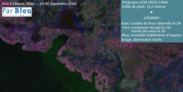
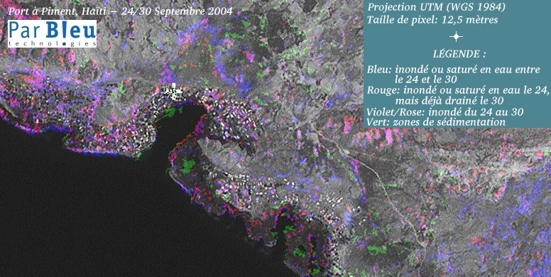
PORT A PIMENT
The size of the area shown is 9.7 x 4.9 kilometers.
UTM geographic coordinates (WGS 1984 Zone 18Q) :
- upper left corner : northing = 2171619 / easting = 706923
- bottom right corner : northing = 2166744 / easting = 716623
Interpretation of the RADARSAT-1 colour composition :
- Pink: flooded by mudflows on September 24th; mud sedimentation observed on September 30th.
- Green: areas totally flooded by water on September 24th; water had recessed on September 30th.
- Blue: population moves; new emergency settlements on September 30th.
- Red: total destruction.
- White: untouched buildings.
Interpretation of the "LANDSAT-7 + change detection" map :
- Violet & pink: Areas flooded or water-saturated during the whole observation period (24-30 September).
- Blue: Areas flooded or becoming water-saturated in the period between the 24th and the 30th.
- Red: Areas flooded or water-saturated on September 24th, and drained on September 30th (flood recession).
- Green : Sedimentation areas and mud deposits.
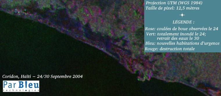
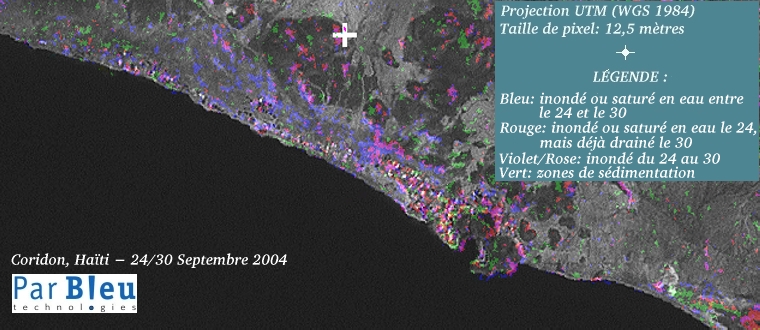
CORIDON
The size of the area shown is 9.5 x 4.1 kilometers.
UTM geographic coordinates (WGS 1984 Zone 18Q) :
- upper left corner : northing = 2165444 / easting = 715686
- bottom right corner : northing = 2161319 / easting = 725186
Interpretation of the RADARSAT-1 colour composition :
- Pink: flooded by mudflows on September 24th; mud sedimentation observed on September 30th.
- Green: areas totally flooded by water on September 24th; water had recessed on September 30th.
- Blue: population moves; new emergency settlements on September 30th.
- Red: total destruction.
- White: untouched buildings.
Interpretation of the "LANDSAT-7 + change detection" map :
- Violet & pink: Areas flooded or water-saturated during the whole observation period (24-30 September).
- Blue: Areas flooded or becoming water-saturated in the period between the 24th and the 30th.
- Red: Areas flooded or water-saturated on September 24th, and drained on September 30th (flood recession).
- Green : Sedimentation areas and mud deposits.
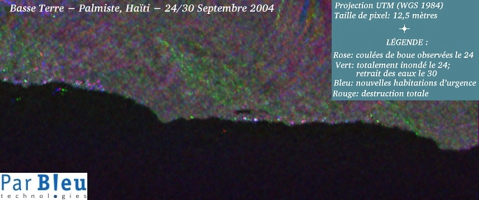
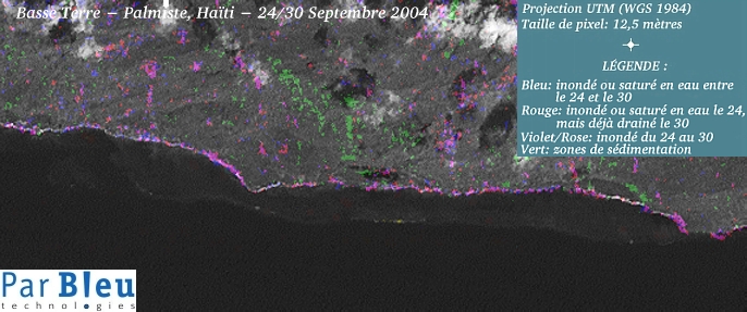
BASSE TERRE - PALMISTE
The size of the area shown is 8.6 x 3.6 kilometers.
UTM geographic coordinates (WGS 1984 Zone 18Q) :
- upper left corner : northing = 2214944 / easting = 738086
- bottom right corner : northing = 2211357 / easting = 746661
Interpretation of the RADARSAT-1 colour composition :
- Pink: flooded by mudflows on September 24th; mud sedimentation observed on September 30th.
- Green: areas totally flooded by water on September 24th; water had recessed on September 30th.
- Blue: population moves; new emergency settlements on September 30th.
- Red: total destruction.
- White: untouched buildings.
Interpretation of the "LANDSAT-7 + change detection" map :
- Violet & pink: Areas flooded or water-saturated during the whole observation period (24-30 September).
- Blue: Areas flooded or becoming water-saturated in the period between the 24th and the 30th.
- Red: Areas flooded or water-saturated on September 24th, and drained on September 30th (flood recession).
- Green : Sedimentation areas and mud deposits.
Produced by PARBLEU TECHNOLOGIES Inc. under mandate of the CANADIAN SPACE AGENCY.
(Standing Offer for Disaster Management Information Products and Services; PWGSC File Number 9F028-014927/008/ST)
Procurement of the original RADARSAT-1 SAR data: Canadian Space Agency, and Radarsat International Inc.
Original RADARSAT-1 images: Copyright Canadian Space Agency / Agence Spatiale Canadienne, 2004.
Copyright (C) PARBLEU Technologies Inc., October 2004