|
||||||
|
|
|
|
|
|
|
|
"Ciudad Blanca": A major Pre-Colombian Lost City Unveiled in Honduras
The lost city of "Ciudad Blanca" In the eve of the 16th century, a great trading Mayan/Nahua city was flourishing in what is known today as the Mosquito Coast, in North-Eastern Honduras. This city was known by the native Central American peoples, from as far as Panama and Mexico. This city was first referred to under the double name of Xucutaco (Nahuat) and Hueitapalan (Mayan) by Hernán Cortés already in 1526. Cortés himself affirms that he was informed of the existence of this city shortly after he reached the coast of the Gulf of Mexico in 1519. After Cortés was told, Xucutaco-Hueitapalan was an impressive city, comparable in population and in wealth with Mexico/Tenochtitlan itself. After Hernán Cortés had to give up heading to it, the city protected by the impenetrable rainforest of the "La Mosquitia" was ignored by the Spanish conquistadores. With time, Xucutaco-Hueitapalan was left to the jungle by its inhabitants, apparently already in the middle of the 16th century. Nevertheless, indigenous people still remembered it as the legendary White City ("Ciudad Blanca"). The region has long been a site of human occupation and has many archaeological sites. The "Instituto Hondureńo de Antropología e Historia" (IHAH) is conducting studies in the region. The village Las Crucitas del Río Aner is established over one of the largest and most impressive archaeological sites (G. Lara-Pinto and G. Hasemann, 1991: "Leyendas y arqueología: ż Cuántas ciudades blancas hay en la Mosquitia ?" In Murphy, V. (ed.), "La Reserva de la Biósfera del Río Plátano", Ventanas Tropicales, Tegucigalpa (Honduras). pp. 16-19) . It is believed that the fabled Ciudad Blanca awaits discovery within the area. Additional archaeological research in the region may confirm the surmise that its peoples were an important link between major pre-Columbian cultures in North America and South America.
The project to accurately identify and locate the the ruins of Ciudad Blanca has been initiated in November 1997, with the aim to contribute to return to Honduras and to mankind a bright page of their history, and to put the site under protection of the due authorities. To do so, the project was carried out under the auspices of SEPHA, the "Sociedad para la Exploración y la Protección de la Historia de las Americas", between December 1997 and February 1998. The remote sensing part of the project has been kindly supported by the European Space Agency (ESA/ESRIN) in Italy, and by the National Space Development Agency of Japan (NASDA) who generously provided the satellite remote sensing data needed. Identification and location of the lost city has been carried out using
SAR images acquired by the Japanese satellite JERS-1 and by the European
satellite ERS-2.
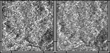
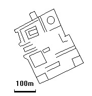
First of all, we tried to identify already known and documented sites in our SAR dataset. As an example, the site known as "Las Crucitas I" is shown below. This site is one of the many archaeological sites that compose Ciudad Blanca. The stereoscopic ERS/JERS-1 unfiltered SAR images are shown below:
The stereoscopic ERS-2/JERS-1 enhanced images are shown below. The features that are visible on this stereoscopic image correspond satisfactorily with the map of the site published by Lara-Pinto and Hassemann.
Similarly, a number of other already documented sites, as well as numerous minor artefacts that are probable ruins scattered in a ca. 20x20 km wide area near have been identified by a careful examination of the processed images.
Nevertheless, an important finding was made during this systematic examination.
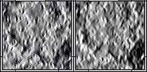
Covering a 3.0x3.5 km wide area in one of the denser part of the forest
(close enough to Las Crucitas to be connected to the sites already documented
there), the ruins of a vast complex of important structures are visible
in the images. The figures shown illustrate the most interesting part
of this area, including what is very probably a vast ceremonial center
(Upper left quadrant of the images). The stereoscopic ERS/JERS-1 unfiltered
SAR images are shown below:
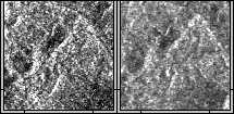
The stereoscopic ERS/JERS-1 enhanced images are shown below:
An enlargement of the important structures located in the upper-left
quadrant of the previous images has been made by photo-interpretation.
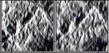
From the elevation map (DEM), and the shadows observed in the images,
one may infer the presence of a pyramid (or a high square-shaped structure)
in the north-western part of the represented area.
The results of a systematic bibliographic research conducted in Honduras,
in the USA and in Europe from January 1998 to May 1998 show that this
site has not been documented until now. It has probably not even been
explored recently. The last report of a place structurally and contextually
similar to this one in La Mosquitia dates back to 1544, when a Spanish
missionary was guided there by local people...
On April 3, 1999, a SEPHA expedition, with PRIVATEERS team members,
after efforts to evercome the obstacles set by nature and by men, reached
the Ciudad Blanca area and definitely confirmed the existence of a pre-colombian
city, located exactly where PRIVATEERS had found it.
The city covers an area as large as announced in 1998. It may have been
one of the largest pre-colombian cities.
This city is likely to have been under the Chibcha cultural influence
which extended from Northern Colombia to South-East Honduras in the 15th
century.
Original JERS-1 data: © NASDA 1996; MITI/NASDA retains ownership
of JERS-1 data; NASDA supports PRIVATEERS N.V. in acquiring the satellite
data (JERS-1 Project #675, awarded on December 11, 1997). |
|
Readers may redistribute this homepage and its locally linked pages to other individuals or institutions for noncommercial use, provided that the text, all html codes, and this notice remain intact and unaltered in any way. No component of this homepage and of its locally linked pages may be resold, reprinted, or redistributed for compensation of any kind without prior written permission from ParBleu Technologies Inc. Last Updated: 06 May 2006 |
|---|
|
|
|
|
|
|
|