
|
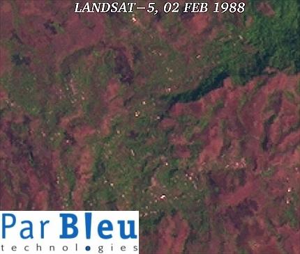
The LANDSAT-5 TM and LANDSAT-7 ETM+ images, subsets of which are shown below, have been acquired in 1988 and 2002, respectively (Courtesy of the University of Maryland, Global Land Cover Facility).
These images have been processed to improve their spatial resolution to 15 meters x 15 meters.
In the 1988 image, forest (in green tones) was still covering half of the area shown (6.5 x 5.5 kilometers), around the - then - village of Bamenka.
In May 2002, the number of small bright points corresponding to the individual houses has considerably increased, which means that the population has increased in the same proportion. Bamenka became a town.
It can be observed that the forest (green tones) has regressed considerably as the population grew. Forest has also regressed on the interior slopes of the old caldera.
Roads are much better visible, and are more numerous. Also the amount of bare soils (in violet), principally around the housing areas has increased.
All these factors together have dramatically raised the risk of landslides, and the points from where a landslide is likely to depart are indicated at the center of the red boxes.
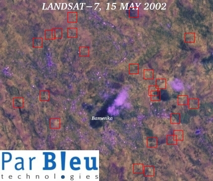
These images have been orthorectified and radiometrically corrected using the Digital Elevation Model built using the RADARSAT-1 and ERS-1 SAR images.
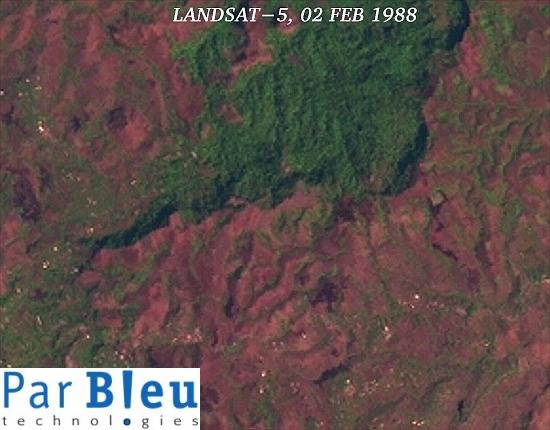
The LANDSAT-5 TM and LANDSAT-7 ETM+ images subsets of which are shown below, (covering 8.3 x 6.5 kilometers) have been acquired in 1988 and 2002, respectively. The area shown is very close to the preceding one (Bamenka). These images have been processed to improve their spatial resolution to 15 meters x 15 meters.
In the 1988 image, forest (in green tones) was still covering the interior of the caldera, as well as most of its outer slopes, north of the village of Djuttitsa. Forest covered all the valleys going down the outer slopes of the caldera.
In 2002, dense alignments of houses along the roads are visible, clearly an indication that the population has grown considerably in the meanwhile.
Deforestation has strongly affected the inner part of the caldera, where less than half of the forest still remains.
In most of the valleys descending the outer slopes of the caldera in the direction of Djuttitsa, forest has been depleted. Bare soils within and around the housing areas have also grown in importance.
This evolution of the landscape has lead to a situation where the threat of landslides becomes the reality. The points from where a landslide is likely to happen, possibly in the direction of housing areas are indicated in the middle of the red boxes.
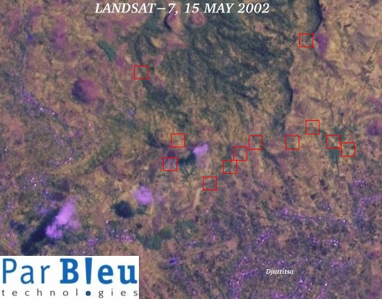
These images have been orthorectified and radiometrically corrected using the Digital Elevation Model built using the RADARSAT-1 and ERS-1 SAR images.
Produced by PARBLEU TECHNOLOGIES Inc.
Operational partners of PARBLEU TECHNOLOGIES Inc. :
 |
 |
 |
| Privateers NV | Treemail | AP Formation |
Copyright (C) PARBLEU Technologies Inc., 2004