|
||||||
|
|
|
|
|
|
|
|
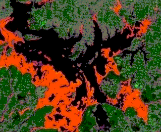
The Yang-Tse-Kiang valley floods projectThis study was carried out to support the studies and research activities on monitoring of natural disasters conducted by CNES, the French Space Agency. Its aim was: improvement of techniques and tools, evaluation of the SAR capabilities, and of its merging capability with optical data sources for the monitoring of natural hazards and temporal variations of the surface state in areas affected by a natural disaster. The study area was the region of the Poyang Hu lake, in the Yang-Tse-Kiang valley (Jiangxi province). This area is among the most severely affected by the giant floods in the Summer of 1999. The data made available by CNES were 3 RADARSAT-1 ScanSAR Narrow Beam mode images: 1 archive image acquired before the floods, and 2 images acquired at 24 days interval (July 27 and August 20, 1999) during the floods. In this project, ParBleu’s team was in charge of the demonstration of the capability of spaceborne SAR to monitor extend and evolution of the floods and their effects over time. Below you find an example.
|
|
Readers may redistribute this homepage and its locally linked pages to other individuals or institutions for noncommercial use, provided that the text, all html codes, and this notice remain intact and unaltered in any way. No component of this homepage and of its locally linked pages may be resold, reprinted, or redistributed for compensation of any kind without prior written permission from ParBleu Technologies Inc. Last Updated: 15 May 2006 |
|---|
|
|
|
|
|
|
|