Agricultural Monitoring
Rice Monitoring
is one of the most important crops in the world. It is an essential food for
more than one third of mankind, especially in tropical Asia, where persistent
cloud cover hinders the acquisition of useful optical imagery from space during
the most part of the year.
Spaceborne Synthetic Aperture Radar (SAR) such as the European ERS and ENVISAT,
the Japanese JERS-1 and ALOS, and the Canadian RADARSAT enable to monitor rice
growth and to retrieve rice acreage, using the unique temporal signature of rice
fields, regardless of the weather conditions.
The multitemporal SAR time series (3 images, represented below in red, green
and blue color composition) presented here has been acquired over Thaďland from
August to December 1993, by the ERS-1 satellite of the European Space Agency
(Original images: courtesy of Dr. J. Aschbacher).
Adequate Privateers NV processing (image calibration, speckle filtering and
classification method) and know-how (agronomy, radar physics) enables to extract
useful information such as land-use, area of rice paddies, etc., from these
satellite SAR images.
The resulting classification can be used to forecast
the rice production, thus getting a valuable economical information, exploitable
either for agriculture management, or on the stock exchange market.
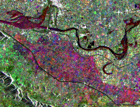
Multitemporal ERS-1 SAR image: Kanchanaburi area, Thaďland:
Rice fields
(violet) exhibit a characteristic temporal response to the radar wave.
The 3 ERS
images have been filtered using the Gamma-Gamma MAP adaptive
speckle filter.
The imaged area covers 19.2 x 17.6 km.
(© Privateers NV 1996).
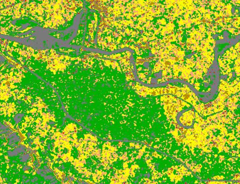
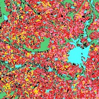
Identification of Rice (green), Cassava (orange) Palmtrees (yellow) and
Housing (brown) in Thaďland
using ERS multitemporal SAR images
(© Privateers NV 1996).
Synergetic Use of Optical and SAR Sensors
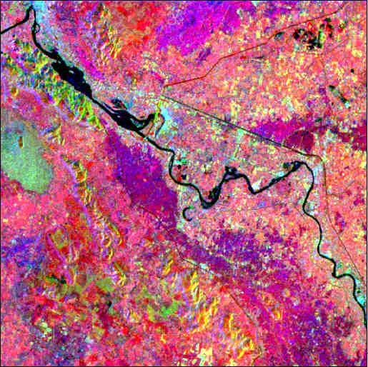
(© Privateers NV 1997)
Much better results can be achieved, using the synergism of optical sensors
(Here, the Japanese MOS-1) and SAR sensors (here the European ERS-1 (C-band) and the
Japanese JERS-1 (L-band) SAR's).
The methodology used to finally obtain this
classification derives from Privateers NV R&D carried out in 1996/1997.
In this classified image (shown area covers 26x26 km), rice, sugarcane, cassava,
sunflower, maize, pineapple, plantations, and forest are identified (for commercial
reasons, year and legend are omitted and spatial resolution has been degraded).
Related Publications:
- E. Nezry, F. Zagolski, A. Lopes, F. Yakam-Simen: "Bayesian filtering of
multi-channel SAR images for detection of thin details and data fusion", Proceedings
of SPIE, Vol. 2958, pp.130-139, Sept. 1996.
- E. Nezry, F. Yakam-Simen, I. Supit and F. Zagolski:
"Retrieval
of environmental and geophysical parameters through Bayesian fusion of ERS and RADARSAT data",
Proceedings of the 3rd ERS Symposium, Florence (Italy), 17-21 March 1997.
European Leaders for Early Crop Acreage Estimation using Spaceborne
SAR Remote Sensing
 For the first time in Europe, the real-time, early in the agricultural
season (winter) , acreage estimation of economically important crops
(cereals, etc.) and of non-cultivated (set-aside) land in Europe has been
successfully carried out under Privateers NV leadership and management.
For the first time in Europe, the real-time, early in the agricultural
season (winter) , acreage estimation of economically important crops
(cereals, etc.) and of non-cultivated (set-aside) land in Europe has been
successfully carried out under Privateers NV leadership and management.
Operations were conducted during from November 1994 to February 1995 (Test areas
in Spain, Italy, France), using ERS SAR images and a similar methodology in the
framework of the ERS-1 (ESA) Pilot Project PE-FRNE.
Related Publication:
|