HAITI : FLOOD EFFECTS after the TROPICAL STORM "JEANNE"
(21-24 September 2004)


Status of operations :

  • Request received from OXFAM QUEBEC, September 24, 2004.
  • Emergency mode engaged under mandate of the Canadian Space Agency on September 27, 2004.
  • RADARSAT-1 radar imagery successfully acquired over Haïti by the Canadian Space Agency and Radarsat International on September 24, and September 30, 2004.
  • RADARSAT-1 radar images received by PARBLEU Technologies Inc. on September 29 and October 05, 2004.
  • Processing of the RADARSAT-1 radar imagery engaged, and production of damage assessment maps in production at PARBLEU Technologies Inc.
  • First high resolution damage assessment maps made available on-line on October 05, 2004.
  • Operation completed: October 18, 2004.
  • Letter of Appreciation received from OXFAM Québec on November 17, 2004.

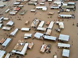
The area that has been surveyed extends over 100 x 80 kilometers, in the départements of "Nord-Est" and "Artibonite".

All speckle filtered images and damage assessment maps (processing by ParBleu Technologies Inc.) are produced in cartographic projection UTM WGS 1984 (Zone 18 Q), and at a spatial resolution of 15 meters x 15 meters (in some case, at 12.5 meters x 12.5 meters).
On the global map below, crosses are spaced every 10 kilometers, at UTM coordinates that are a multiple of 10000.
On all other maps, crosses are spaced every 5 kilometers, at UTM coordinates that are a multiple of 5000.

Credits: OXFAM Québec

The Surveyed Area in Haïti


CLOSE-UP OVER SPECIFIC TOWNS

BRIDGES STATUS


DAMAGE ASSESSMENT MAPS

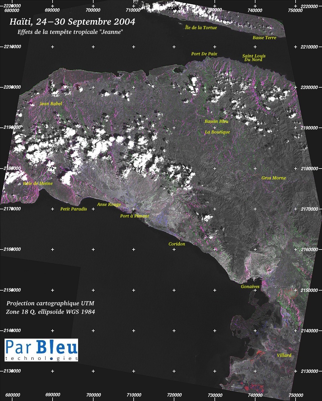
The map below is a medium resolution damage assessment map (spatial resolution of 75 meters x 75 meters) of the overall area monitored by the Canadian RADARSAT-1 satellite.
For an easier legibility, the effects detected using multi-temporal RADARSAT-1 radar imagery have been superimposed on top of a LANDSAT-7 Panchromatic image of July 3rd, 2003.

This is a clickable map :

Wherever the option is available, click on your area of interest to acquire a detailed close-up view at a spatial resolution of 15 meters x 15 meters.

Gonaives Saint Louis du Nord Bassin Bleu - La Boutique Anse Rouge Port de Paix Gros Morne Basse Terre - Palmiste, Île de la Tortue Jean Rabel Baie de Henne Port A Piment Coridon Petit Paradis Villard Click to Enlarge Click to Enlarge Click to Enlarge Click to Enlarge Click to Enlarge Click to Enlarge Click to Enlarge Click to Enlarge Click to Enlarge


Related Pages at the NASA Earth Observatory :


Produced by PARBLEU TECHNOLOGIES Inc. under mandate of the CANADIAN SPACE AGENCY.
(Standing Offer for Disaster Management Information Products and Services; PWGSC File Number 9F028-014927/008/ST)
Procurement of the original RADARSAT-1 SAR data: Canadian Space Agency and Radarsat International Inc.
Procurement of the LANDSAT-7 ETM+ image: Courtesy of the University of Maryland (URL: http://glcf.umiacs.umd.edu)

Operational partners of PARBLEU TECHNOLOGIES Inc. :
Privateers NVTreemailAP Formation

Copyright (C) PARBLEU Technologies Inc., October 2004