Landslide Assessment & Prevention of Future Risks
Monts BAMBOUTOS, CAMEROON
September 2003 / May 2004
THE DISASTER
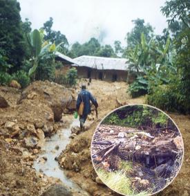 |
In June and July 2003, a series of important landslides happened in the Monts Bamboutos (western Cameroon) and in their surroundings, causing a large number of casualities and leaving many people homeless.
In particular, the landslide at Maghah caused 20 deaths, the one in Batibo 3 deaths, the one in Bafou 2 deaths, and the most important, at Wabane caused one death and very important material damage. 309 houses have been destroyed.
These landslides are associated to the very heavy precipitations of the rain season in 2003 (rain season from end of May to end of October).
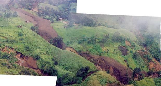
They are becoming now a recurrent threat in these areas which are located in very strong relief of volcanic origine.
In front of what is now considered a permanent high risk, and in the expectable perspective of generalized landslides and of a major disaster in these densely populated mountains, the local and national authorities remain powerless with regard to the decisions to be taken.
In any case, accurate regional mapping was considered an urgent necessity, to determine the risk areas, and to define the sectors where the population could eventually be moved into safety.
|
 |
 |
|---|
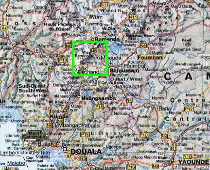
| Location of the study area in Cameroon |
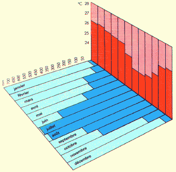
Mean climatic conditions (rainfall & temperature in the lowlands) |
THE OPERATIONS
Status of operations :
- Request received from the "Centre de Recherche des Hautes Terres", University of Dschang, and from the Cameroon Environmental Watch (CEW), on September 21, 2003.
Other users are: the Cameroonese Red-Cross, the "Institut National de Cartographie", the communes, the prefectures, etc.
- Action engaged under mandate of the Canadian Space Agency on October 20, 2003.
- Collection of satellite imagery: ERS-1 SAR (2 frames), LANDSAT-4 TM (1 frame), LANDSAT-5 TM (1 frame), LANDSAT-7 ETM+ (2 frames), and LANDSAT-7 PAN (2 frames), September/December 2003.
- A RADARSAT-1 SAR Image (SGC, standart beam S7) has been acquired by RADARSAT International on November 11, 2003, and has been made available to the project by the Canadian Space Agency.
- Field trip to the Bamboutos mountains in Cameroon, with documentation of the landslides, and collection of GPS mesurements. Local contact and meetings with the end-users. (December 2003 - January 2004)
- A first database containing satellite imagery from 1988 to 2003 as well as topographic maps built using satellite radar (SAR) imagery has been delivered to the end-users at the end of February 2004.
This database forms the base of a regional Geographic Information System (GIS), in order to spatialize all the related information collected.
This delivery has been done timely, before the rain season of 2004, which is when a new series of landslides occurred.
- End of Canadian Space Agency / ParBleu project on February 28, 2004.
- In May 2004, the integration and analysis of a TERRA-ASTER image acquired on March 08, 2004 contributed to the identification of landslides risks for the next rain season, in the summer 2004.
- Results: no more casualities in the monitored area in 2004, 2005 and 2006.
- The project will follow-on soon, since the threat is still present:
- Collection of additional satellite imagery
- Collection of ancillary information
- Integration into a regional Geographic Information System (GIS)
|
The area that has been surveyed extends over 70 x 50 kilometers (latitude 5°15' to 5°50' N / longitude 9°50' to 10°15' E).
All satellite maps shown in these pages are produced in cartographic projection UTM WGS 1984 (Zone 32 N),
and at a spatial resolution of 30x30 meters and/or 15x15 meters.
MAIN THREAT: THE BAMBOUTOS CALDERA
OTHER THREATENED AREAS IDENTIFIED
TOPOGRAPHY OF THE MONTS BAMBOUTOS
THREATS FOR THE 2004 RAIN SEASON
Related Pages at the
NASA
Earth Observatory (June 02, 2004) :
Produced by PARBLEU TECHNOLOGIES Inc. under mandate of the CANADIAN SPACE AGENCY
(Standing Offer for Disaster Management Information Products and Services; PWGSC File Number 9F028-014927/A)
- Procurement of the original RADARSAT-1 SAR image: Canadian Space Agency (CSA), and Radarsat International
- Procurement of the original ERS-1 SAR frames: Global Rain Forest Monitoring project (GRFM)
(under Pilot Project granted by the Joint Research Center of the EU).
- Procurement of the LANDSAT-4, LANDSAT-5 and LANDSAT-7 (TM, ETM+ and Panchromatic) images:
Courtesy of the University of Maryland, Global Land Cover Facility (URL:
http://glcf.umiacs.umd.edu).
- Procurement of the TERRA-ASTER image: Courtesy of MITI, ERSDAC, JAROS, and the U.S./Japan ASTER Science Team
(URL:
http://asterweb.jpl.nasa.gov).
Operational partners of PARBLEU TECHNOLOGIES Inc. :
 |
 |
 |
| Privateers NV | Treemail | AP Formation |
Copyright (C) PARBLEU Technologies Inc., 2003/2004